
Flock Condor Cameras: What They Are, How to Spot Them, Where They Are
New Hanover County’s Flock contract included something most residents never heard about: eight Condor cameras. Not plate readers — pan-tilt-zoom video cameras that can follow people. Here is what a Condor is, how to recognize one, and where the county’s eight are hiding.
When people picture a Flock camera, they picture the Falcon — the small fixed box that photographs the back of a car and reads the plate. The Condor is a different animal. It is a pan-tilt-zoom (PTZ) video camera: dual-lens, solar-powered, and able to swivel, tilt, and zoom in on people — to follow someone on foot, hold on a face, or read the screen of the phone in your hand. New Hanover County’s Flock contract included eight of them, and the county has never explained where they all are or why it bought video cameras for a “license plate reader” program.
What a Condor is — and how it differs from a plate reader
Flock sells two very different products. The Falcon is a fixed automated license plate reader: it captures a still image of a passing vehicle and its plate. The Condor is a video camera on a pan-tilt-zoom mount — the kind of camera that watches a scene, not a lane. It records live and recorded video, it moves, and it magnifies. A Falcon reads your tag; a Condor can watch a person. That distinction is the whole point: a program sold to the public as “plate readers” quietly included eight cameras built to surveil people and places.
This is not hypothetical. When Flock left dozens of Condor feeds exposed on the open internet, the technologist Benn Jordan and 404 Media watched the cameras pan, tilt, and zoom in on people — a jogger, pedestrians, and unattended children on a playground, one feed close enough to read the screen of a passing phone. That is what a “license plate reader” program actually bought.
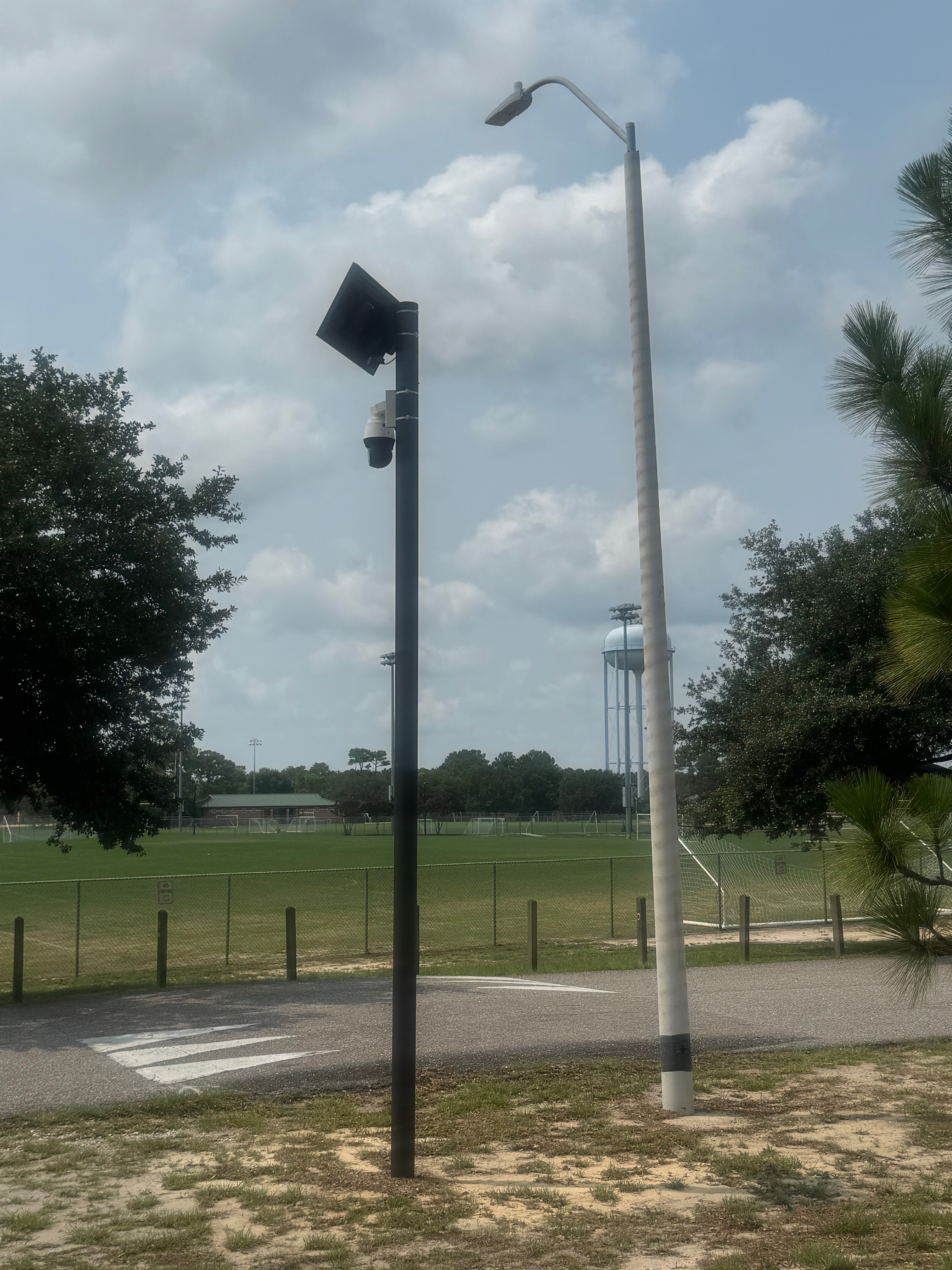
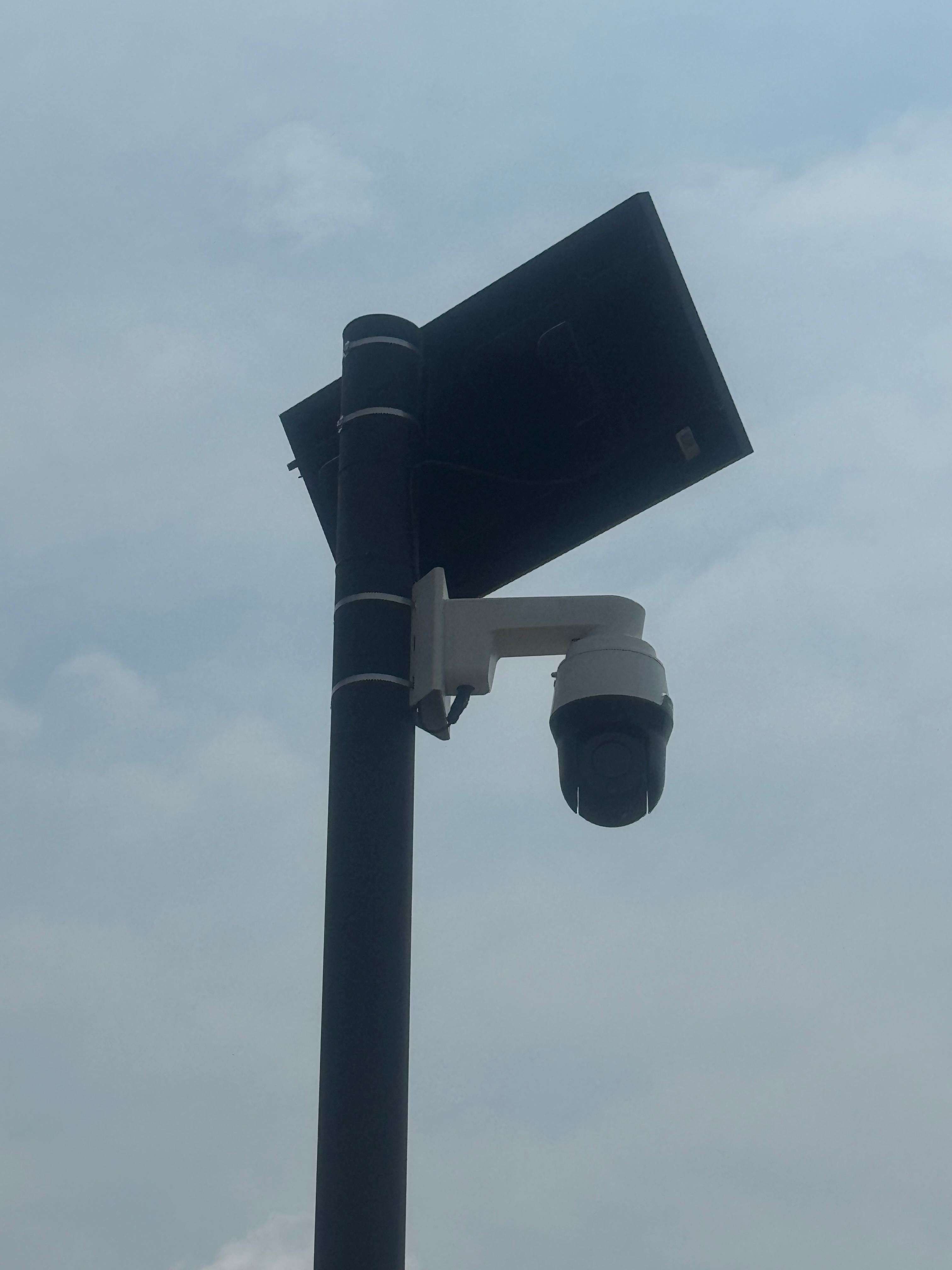
How to spot a Condor
Once you know what to look for, a Condor is hard to un-see. Look for:
- A black PTZ dome (a rounded, swiveling camera head) mounted on a white bracket or arm — not the flat rectangular box of a Falcon plate reader.
- A solar panel and a small battery box on the same pole.
- Mounting that lets it look around — often higher, aimed at an intersection, an entrance, a park, or a lot, rather than straight down a single traffic lane.
Watch out for look-alikes: NCDOT traffic cameras, private security domes, and other vendors’ cameras can resemble a Condor. If you’re not sure, photograph it (from public property) and send it to us — we’ll help identify it and add confirmed ones to the map. Email info@DeFlockILM.org.

Where the Condors are in New Hanover County
The county’s contract lists eight Condor cameras. Their locations are redacted from the public records, so residents have been finding them one at a time, from the public right-of-way. Seven of the eight have now been located — including two at Ogden Park. One remains unaccounted for. Here is the map, followed by each one and what it is pointed at.
Red pins: the seven located Condors — two of them at Ogden Park. Gray pin: a look-alike at Long Leaf Park that is not a Flock camera (see below). The S. 17th at The Pointe pin is approximate; the two Ogden Park pins are exact GPS. Crowd-sourced ALPR map also at maps.deflock.org. Spotted one we don’t have? Send us the location.
Condor #1 — Haven Place, Castle Hayne Road (NC 133)
The first Condor a resident located, on July 3, 2026. It stands on Castle Hayne Road (NC 133), between the Circle K at Oakley Road and Old Mill Road, and appears aimed toward the Circle K lot. It sits directly beside Haven Place — a 35-home Habitat for Humanity neighborhood, under construction on land New Hanover County itself donated. The same county that donated land so working families could own a first home parked a county-run video camera at the edge of that neighborhood. (Location on the map.)

Condor #2 — Veterans Park, pointed at the youth soccer fields
The second Condor sits beside the Pleasure Island Soccer Association fields at Veterans Park, off Pilots Ridge Road in Myrtle Grove — GPS 34.103778, −77.904627 (open the map). It faces the fields. Veterans Park is a 212-acre county complex that also contains Ashley High School, Murray Middle School, and Anderson Elementary School — on a weekend, one of the busiest youth-sports sites in the county. This one is not aimed at a road at all: it sits low and is trained on a place where children play. A camera high over a highway is positioned to watch traffic; a camera lowered and aimed at a playground is positioned to watch people. The county has never explained why one of its eight points there.
Condor #3 — S. 17th Street at Greenlawn
A white pan-tilt-zoom dome on a horizontal arm, roughly 25–30 feet up a wooden utility pole in the easement beside Greenlawn Memorial Park — GPS 34.19552, −77.92101. It commands both directions of traffic on S. 17th Street and sees the parking lots of adjacent businesses.

Condor #4 — S. 17th Street at The Pointe
Located after a tip from a former law enforcement officer, near 3296 S. 17th Street. It overlooks a public walking path beside The Pointe theater and both lanes of S. 17th Street.

Condor #5 — S. College Road (NC 132)
Reported by a concerned citizen, on a pole across from the Firestone Tire store, overlooking S. College Road (NC 132) and the Dollar Tree — GPS 34.19906, −77.88860, one of the busiest commercial corridors in Wilmington.

Condor #6 — Ogden Park, by the ball fields (34.272098, −77.824540)
The first of two Condors at Ogden Park — and residents have now confirmed both. This one stands beside the county ball fields, off Ogden Park Drive near the Gordon Road entrance — GPS 34.272098, −77.824540 (open the map). It carries the Flock signature the look-alikes lack: a dark PTZ dome below a solar panel, on Flock’s own black pole. It is also a second device at this entrance — NCDOT’s encroachment records list a permitted solar plate reader at “Gordon Rd @ Ogden Park Dr,” so the county has both a Falcon plate reader and a live-video Condor covering the same park.

Condor #7 — Ogden Park, Military Cutoff side (34.266132, −77.835649)
The second Ogden Park Condor, on the west side of the park near Military Cutoff Road / US 17 Business — GPS 34.266132, −77.835649 (open the map). Same hardware: a dark PTZ dome and a solar panel on a Flock black pole, set at the tree line facing the road. Two live-video cameras on a single county park is a scale of coverage the “plate reader” framing never accounted for.


Two kinds of pole — why half of them look like something the power company put up
The county’s Condors are not all mounted the same way, and the difference is worth seeing. Some sit on Flock’s own tall black poles, topped with a solar panel and a battery box — the Haven Place and Veterans Park cameras are built this way, self-powered and set down anywhere without wiring. Others are strapped 25 to 30 feet up an existing wooden telephone pole, drawing power from the pole and reaching out over the road — the three cameras on S. 17th Street and College Road are mounted this way, a white dome on an arm below a whip antenna. Same camera, same capability; only the pole changes. That is part of why they are hard to spot: half of them look like Flock hardware, and half look like utility equipment.
Not every camera on a pole is a Condor
While mapping, residents flagged a camera at Long Leaf Park as a possible Condor. It is not — and telling the difference matters. The Long Leaf Park camera is a white dome PTZ made by Axis Communications, a different manufacturer, mounted on a black park-style pole with a separate antenna box and no solar panel. The tell is the hardware: a Flock Condor carries Flock’s own dome-and-solar rig; the Axis unit does not.

Two things are worth adding. First, “not Flock” does not mean “not surveillance.” A PTZ camera like this pans, tilts, and zooms, and can be paired with software to read plates — so it may be an ALPR-capable camera in its own right. What it is not is a Flock Condor, which is the only reason it does not count toward the county’s eight. Second, Long Leaf Park is New Hanover County property, and “not Flock” may not mean “not connected to Flock”: Flock sells a software suite called Wing that pulls third-party IP cameras — Axis units among them — into FlockOS, the same platform that runs the county’s Condors. New Hanover’s own Flock contract (No. 25-0364) references Wing and a custom Fusus API integration. What the records do not show is whether the county has connected this particular camera. The capability exists; whether this camera is wired into the same platform as the Condors is a fair question for the next records request.
Find one, and put it on the map
Two Condors are still unaccounted for. The only way the public gets an honest map is the way we got these six: neighbors, on foot, documenting what is on their own streets. This is documentation, not confrontation — photograph cameras from the public sidewalk or roadside, never from private property, and never touch, cover, or block a camera. A photo from the public right-of-way is all it takes, and it is completely lawful.
Reports go on the public DeFlock map through the free DeFlock app — the same tool our founder used to log the first Condor:
- Download the free DeFlock app (“DeFlock.me” on the App Store or Google Play) and make a free OpenStreetMap account.
- Stand near the camera (on the public sidewalk), add a point at the pole, and drag the pin to the exact spot.
- Pick the vendor — Flock Safety — and the type. For a Condor, that is a PTZ / video camera, not an ALPR plate reader. Set the direction it faces and the operator (New Hanover County Sheriff’s Office).
- Upload. It publishes to the map for everyone.
Prefer not to use the app? Submit straight from the web at deflock.org/report, or follow the official DeFlock mobile guide. Prefer hunting cameras by their wireless signal? We wrote a whole guide to mapping the cameras yourself. Then tell us what you found: info@DeFlockILM.org.
Placed in the public right-of-way — without permits
Several of the Condors sit in the state highway right-of-way, which requires an NCDOT encroachment permit. The records show no such permits for them. DeFlockILM filed a formal encroachment complaint with NCDOT over the Condors placed in state rights-of-way without authorization. Cameras the public wasn’t told about, in locations the county redacts, on poles the state never permitted.
The rest of the Cape Fear: New Hanover stands alone
Among the five Cape Fear counties, only New Hanover County runs Condors. The others bought the plate readers, not the video cameras:
- Brunswick County — the Sheriff’s Office runs Falcon plate readers and states on its own ALPR page that it does not use the video-capable models.
- Pender County — the Sheriff’s invoices show plate readers and no Condor video at all.
- Onslow County — runs SoundThinking’s PlateRanger, a different vendor entirely, not Flock Condors.
- Columbus County — Flock plate readers, with no Condor on the record.
So the video cameras that can follow a person are, in this region, a New Hanover County purchase — and the one that most needs explaining.
New Hanover canceled Flock — but the Condors are still on
On September 8, 2026, the New Hanover County Commissioners voted 4–0 to cancel the county’s Flock plate-reader contract. But the cancellation covered only the plate readers. The county’s own termination letter states there are “no changes to the Condor cameras portion of the contract” — the eight Condors keep running under a separate line, monitored in real time. (The full story of the refund and the Condors that stayed on.)
Only the Board of Commissioners and the Sheriff can turn the Condors off. If you live in New Hanover County, that is who to ask.
You’re not a suspect. So stop being tracked like one.
It takes one minute. Add your name — then tell the officials who represent you to take the cameras down.